• <samp id="ossg8"></samp>
    <tbody id="ossg8"><nobr id="ossg8"></nobr></tbody>
    <menuitem id="ossg8"><strong id="ossg8"></strong></menuitem>
  • <samp id="ossg8"></samp>
    <menuitem id="ossg8"><strong id="ossg8"></strong></menuitem>
  • <menuitem id="ossg8"><ins id="ossg8"></ins></menuitem>

  • <tbody id="ossg8"><nobr id="ossg8"></nobr></tbody>
    <menuitem id="ossg8"></menuitem>
        Skip Navigation Links
        Centers for Disease Control and Prevention
         CDC Home Search Health Topics A-Z

        Preventing Chronic Disease: Public Health Research, Practice and Policy

        View Current Issue
        Issue Archive
        Archivo de n鷐eros en espa駉l


        Emerging Infectious Diseases Journal
        MMWR


         Home 

        Volume 5: No. 3, July 2008

        TOOLS AND TECHNIQUES
        Use of BRFSS Data and GIS Technology for Rapid Public Health Response During Natural Disasters


        TABLE OF CONTENTS


        Translation available Este resumen en espa駉l
          Ce r閟um?est en fran鏰is
          本摘要中文版
          本摘要中文版
        Print this article Print this article
        E-mail this article E-mail this article:


        Send feedback to editors Send feedback to editors
        Download this article as a PDF Download this article as a PDF (850K)

        You will need Adobe Acrobat Reader to view PDF files.


        Navigate This Article
        ?/td> Abstract
        ?/td> Introduction
        ?/td> Data and Technology
        ?/td> Assessment Techniques
        ?/td> Sample Assessment
        ?/td> Flexibility of the BRFSS and GIS
        ?/td> Acknowledgments
        ?/td> Author Information
        ?/td> References
        ?/td> Tables


        James B. Holt, PhD, MPA, Ali H. Mokdad, PhD, Earl S. Ford, MD, MPH, Eduardo J. Simoes, MD, MSc, MPH, William P. Bartoli, MS, George A. Mensah, MD

        Suggested citation for this article: Holt JB, Mokdad AH, Ford ES, Simoes EJ, Bartoli WP, Mensah GA. Use of BRFSS data and GIS technology for rapid public health response during natural disasters. Prev Chronic Dis 2008;5(3). http://www.cy118119.com/pcd/issues/2008/
        jul/07_0159.htm
        . Accessed [date].

        Abstract

        Having information about preexisting chronic diseases and available public health assets is critical to ensuring an adequate public health response to natural disasters and acts of terrorism. We describe a method to derive this information using a combination of data from the Behavioral Risk Factor Surveillance System and geographic information systems (GIS) technology. Our demonstration focuses on counties in states that are within 100 miles of the Gulf of Mexico and the Atlantic Ocean coastlines. To illustrate the flexible nature of planning made possible through the interactive use of a GIS, we use a hypothetical scenario of a hurricane making landfall in Myrtle Beach, South Carolina.

        Back to top

        Introduction

        The aftermaths of recent natural disasters have highlighted the catastrophic social, economic, and public health impact that these events can have. In December 2004, the Indian Ocean tsunami killed 226,408 people, rendered 1,033,464 homeless, adversely affected an additional 1,356,339, and cost an estimated $7,710,800,000 in damage (1). Between July and October 2005, hurricanes Dennis, Katrina, Rita, and Wilma resulted in the deaths of 1852 people and affected 830,000 more, many of whom became homeless (2).

        Although much attention rightly has been given to the immediate safety and acute health needs of these people (3-6), less emphasis has been devoted to the needs, both immediate and long-term, of people with preexisting health conditions. Often, the magnitude of the public health impact is determined by the underlying vulnerabilities of the affected population, including people with chronic diseases, pregnant women, and children, and by the extent of damage to the local public health infrastructure. The public health assets of surrounding communities, which could be used to mitigate damage and provide service to evacuees, also play important roles. Lessons learned from recent disasters suggest that prospective assessment of existing health problems and available resources is essential for effective preparedness and response. Unfortunately, these data are not readily available for most communities at risk.

        Hurricane Katrina, which devastated the third most populated metropolitan area on the U.S. Gulf Coast, taught us that this prospective assessment is essential (7). Interruptions in treatment brought on by a disaster increase the risk of death or serious complications for people who require insulin to control their diabetes, for heart attack survivors who take daily clot-preventing medications, for people with severe chronic lung disease who require home oxygen therapy, and for people with kidney failure who are treated with outpatient hemodialysis. Natural disasters often interfere with or totally disrupt the availability of supplemental oxygen supplies. Power outages prevent the use of dialysis and other medical equipment and can exacerbate existing health conditions by preventing the cooling or heating that patients require. Conditions of extreme heat and cold are particularly dangerous for elderly people, pregnant women and their fetuses, neonates, and young children. Lastly, chronic diseases are often aggravated by the lack of food and clean water and the increased levels of physical and mental stress that accompany a disaster (7).

        To effectively plan a response to natural disasters, such as hurricanes, floods, and earthquakes, and man-made disasters, such as acts of terrorism, public health officials and first responders need analytic methods to quickly estimate the number of people who will be affected and the subpopulations that are at particular risk. Equally as important is the ability to locate and quantify facilities such as hospitals and schools that are needed during a response. Given the complexity and the sometimes lengthy lead times required for state and local health officials to prepare personnel, facilities, and medical supplies for a public health response, establishing a baseline dataset in advance of a disaster is vital. Preferably, this dataset would be updated frequently and would have the analytic tools needed to model contingencies and develop effective responses, including estimates of the required quantities of essential maintenance medication and treatment for patients with chronic diseases (7).

        In the wake of the 2005 hurricanes, Mokdad et al (7) addressed the need for a surveillance tool to support disaster response planning that gives appropriate consideration to people with chronic diseases and other vulnerable populations. Recommendations were that the surveillance tool should have three components: 1) a means of determining the baseline magnitude of the disaster and needs of these vulnerable people, 2) a means of assessing needs and levels of response in an affected area during a disaster, and 3) a means of monitoring the long-term effects of a disaster.

        In response to these recommendations, we demonstrate how the Behavioral Risk Factor Surveillance System (BRFSS) and geographic information system (GIS) technology available from Centers for Disease Control and Prevention’s (CDC’s) National Center for Chronic Disease Prevention and Health Promotion can be combined to meet the need for rapid assessment of subpopulations at risk and to identify available resources in advance of a disaster. We also note the value of the BRFSS in addressing the second and third components of the recommended surveillance tool.

        Back to top

        Data and Technology

        We used data from the BRFSS (8-11) to estimate the prevalence of health risk factors and chronic diseases, the 2000 U.S. census (Summary Tape File 3 [SF-3] Long Form) (12) to obtain a sociodemographic baseline, and the American Hospital Association Annual Survey Database to quantify hospital resources (13). Environmental Systems Research Institute, Inc (ESRI) provided data on school locations and attributes by collating data from the U.S. Geographic Names Information System and the U.S. Board of Geographical Names, both of which collect and archive data on civic institutions as part of the U.S. Geological Survey’s National Map program (14).

        The BRFSS, operated by state health departments with assistance from CDC, collects data on many of the behaviors and conditions associated with the leading causes of morbidity and mortality in the United States. Each month, trained interviewers use an independent probability sample of households with telephones to collect data from the noninstitutionalized population aged 18 years or older. A detailed description of the survey methods is available elsewhere (15). All questionnaires are available online (www.cy118119.com/brfss/questionnaires). We used data from the District of Columbia and the 21 states whose land area partially or completely extends to within 100 miles of the Gulf of Mexico and the Atlantic Ocean coastlines. To ensure that each county-level prevalence estimate was based on a combined sample of at least 50 responses, we combined data from survey years 2001, 2003, 2004, and 2005 (N = 904,531).

        BRFSS respondents for the years that we used answered questions pertaining to high blood pressure, use of blood pressure medication, high blood cholesterol, heart attack, heart disease, stroke, diabetes, asthma, and pregnancy. From the answers, we estimated the prevalence of these medical conditions for the general population. We used SAS 9.1.3 (SAS Institute Inc, Cary, North Carolina) and the proc surveymeans design statement to account for the complex sampling design of the BRFSS.

        GIS technology has been defined in various ways (16,17), but for succinctness we prefer the definition of Lo and Yeung: “a set of computer-based systems for managing geographic data and using these data to solve spatial problems” (18). For our demonstration, we used ArcGIS 9.2 (Environmental Systems Research Institute, Inc, Redlands, California), which enabled us to merge, analyze, and display data and results in one software application. We obtained GIS shapefiles (i.e., geographic boundary files) of U.S. states and counties (hereafter, counties refers to counties and county-equivalents: parishes in Louisiana and independent cities in Virginia) from ESRI, and extracted the coastlines of the Atlantic Ocean and the Gulf of Mexico through GIS-assisted manual editing. The resulting coastline shapefile became the baseline from which we constructed 50- and 100-mile buffers. We chose these radii arbitrarily, as reasonably good markers for the differences in area damage that result from hurricanes of various magnitudes.

        Back to top

        Assessment Techniques

        To estimate the underlying populations at risk within the two buffer zones, we determined which counties the zones comprised. We mapped the population-weighted centroid (center of mass) of the District of Columbia and each county and conducted two spatial joins (a GIS overlay function) between population-weighted centroids and county shapefiles to extract those counties with centroids in both buffer zones (≤50 miles and >50–100 miles from the coastline) (Figure 1). We used population-weighted centroids, which are analogous to centers of gravity, rather than geometric centroids because population-weighted centroids more accurately reflect the spatial distribution and density of county populations.

        Map

        [ View enlarged image ]

        Figure 1. Counties with population-weighted centroids within 50- and 100-mile radius of Gulf of Mexico and Atlantic Ocean coastlines, 2000. Data from U.S. Census Bureau (12).

        We imported county sociodemographic data from the 2000 U.S. census (19) into ArcGIS in database format and joined the database to the county shapefile, using county FIPS (Federal Information Processing Standards) codes as the primary join key. The National Institute of Standards and Technology issues a standardized set of numeric codes to ensure uniform identification of geographic entities by all federal government agencies (19,20). These data include variables on total population, age distribution, racial/ethnic distribution, housing units and occupancy status, median housing values, school enrollment by type of school, prevalence of disability by age group, median family income, and prevalence of poverty by age group. We also imported county public health data from the BRFSS into the GIS database. Once the data were joined to the county shapefiles, summary statistics and ratios of the individual variables were computed by area.

        To demonstrate the usefulness of a GIS in a real-time emergency, we applied the technology to a hypothetical scenario in which a hurricane makes landfall in the vicinity of Myrtle Beach, South Carolina. We created a 100-mile buffer around the point location for the city of Myrtle Beach and used the GIS to extract those counties with population-weighted centroids within this buffer zone (Figure 2). All values for population demographics, people with chronic diseases, and resources for emergency response were contained within the extracted county-level geographic records in the GIS.

        Map

        [ View enlarged image ]

        Figure 2. Counties with population-weighted centroids within a 100-mile radius and major cities within a 200-mile radius of Myrtle Beach, South Carolina, 2000. Data from U.S. Census Bureau (12).

        Back to top

        Sample Assessment

        According to the 2000 U.S. census, 139,441,051 people, or approximately 50% of the U.S. population at that time, lived in the total area included in our demonstration (i.e., 21 states and the District of Columbia) (12). Of these people, 66% lived in counties with population-weighted centroids within 100 miles of the Gulf of Mexico and Atlantic Ocean coastlines (57% within ≤50 miles, 9% from >50–100 miles). Note that in our assessment, data for the two coastal buffer zones overlap, so that data for the area in the 100-mile zone include data for the area in the 50-mile zone.

        Our assessment shows that approximately 18.2 million people within 100 miles of the coastline were likely to be at particular risk in a disaster because of their age (either <5 years or ≥65 years); approximately 13.8 million, because of being school-aged (i.e., being enrolled in nursery school, kindergarten, or elementary school); and approximately 208,246, because of being inpatients in a hospital (estimated by multiplying the number of hospital beds by a 70% occupancy rate) (Table 1).

        Data joined with the GIS provide the number of hospitals, hospital beds, and hospital workers in total and by state for each zone (Table 2) and the estimated number of people with selected medical conditions in total and by state for each zone (Table 3). By combining the information in Tables 2 and 3, health officials can compare the extent of chronic diseases and the availability of response resources in any coastal area. The number of hospitals in a local area varies greatly throughout each coastal zone, as does the number of beds in a single hospital (Figure 3). As would be expected, areas with large populations tend to have access to greater numbers of hospitals and hospital beds, but the ratio of people to hospitals and of people to hospital beds may actually be lower in highly populated urban areas. This reality underscores the importance of establishing baseline data on the at-risk population and the resources available to respond to surges in demand.

        Map

        [ View enlarged image ]

        Figure 3. Locations of hospitals, with number of beds per hospital, in states with land area within 100 miles of the coastline. Data from the American Hospital Association (13).

        For the Myrtle Beach scenario, an estimated 412,364 people would be at particular risk because of their age; 344,105, because of being in nursery, kindergarten, and elementary schools; and 4661, because of being inpatients in a hospital (Table 4). Given that 16% of people in the area live in poverty, many of these vulnerable people would have to rely on the government for evacuation.

        Back to top

        Flexibility of the BRFSS and GIS

        The BRFSS can and has been used to assess needs and levels of response during a disaster and to monitor the long-term effects of a disaster. In response to the unexpected shortfall in the 2004–2005 supply of influenza vaccine, CDC and the Advisory Committee on Immunization Practices (ACIP) recommended prioritizing vaccination for people aged 65 years and older and for others at high risk (21,22). To monitor coverage, the BRFSS added several questions about influenza vaccination, including new questions on priority status and the month and year of vaccination among children and adults (23). Because of the rapid turnaround of BRFSS data, public health officials were able to obtain near–real-time estimates of influenza coverage (24), including county-level estimates based on small-area estimation procedures (25). One study, using data for the New Orleans–Metairie–Kenner, Louisiana, Metropolitan Statistical Area, demonstrated the feasibility of using the BRFSS to estimate baseline information on the number of older adults who may have a disability and thus need assistance in evacuating to shelters or who may need special equipment in the event of a natural disaster (26).

        Flexibility is one of the most useful features of a GIS. By altering the planning assumptions that are entered into the GIS, public health officials can conduct analyses quickly and efficiently on any issue for which data are available. Sources could include the National Hospital Ambulatory Medical Care Survey, which has asked questions in the past that may yield data on hospital preparedness for natural disasters and acts of terrorism (27); state-based trauma system registries, which contain data on mass casualties and trauma (28); and CDC’s National Center for Health Statistics, which maintains data on the number of live birth deliveries by county, from which estimates can be derived of the number of pregnant women and neonates at a given time. The salient questions for health officials are: What sources of primary data are readily available? To what extent can the surge capacity of identified assets be ascertained reliably? How generalizable are the outputs, and how sensitive are they to the particular type of disaster?

        Back to top

        Acknowledgments

        The authors thank Dr Wayne Giles, MD, MS, Director, Division of Adult and Community Health, National Center for Chronic Disease Prevention and Health Promotion, CDC, for his support of the BRFSS and GIS technology.

        Back to top

        Author Information

        Corresponding Author: James B. Holt, PhD, MPA, Centers for Disease Control and Prevention, 4770 Buford Hwy, NE, MS: K-67, Atlanta, GA 30341. Telephone: 770-488-5510. E-mail: jgh4@cdc.gov.

        Author Affiliations: Ali H. Mokdad, Earl S. Ford, Eduardo J. Simoes, George A. Mensah, Centers for Disease Control and Prevention, Atlanta, Georgia. William P. Bartoli, Northrop Grumman Information Technology, Atlanta, Georgia.

        Back to top

        References

        1. EM-DAT: Emergency Disasters Data Base. Natural disasters: trends and relationships for the period 1900–2005. Brussels (BE): Centre for Research on the Epidemiology of Disasters. http://www em-dat net/disasters/trends.htm#Natural 2006.
        2. EM-DAT: Emergency Disasters Data Base. Country profile for natural disasters: United States, 1900?005. Brussels (BE): Centre for Research on the Epidemiology of Disasters. http://www.em-dat.net/disasters/Visualisation/profiles/natural-table-emdat,php?country=United+States&Submit= Display+Country+Profile 2006.
        3. Farmer JC, Carlton PK Jr. Providing critical care during a disaster: the interface between disaster response agencies and hospitals. Crit Care Med 2006;34(3 Suppl):S56-9.
        4. Pretto EA Jr, Safar P. National medical response to mass disasters in the United States. Are we prepared? JAMA 1991;266(9):1259-62.
        5. Noji EK. Public health issues in disasters. Crit Care Med 2005;33(1 Suppl):S29-33.
        6. Noji EK, Toole MJ. The historical development of public health responses to disaster. Disasters 1997;21(4):366-76.
        7. Mokdad AH, Mensah GA, Posner SF, Reed E, Simoes EJ, Engelgau MM, and the Chronic Diseases and Vulnerable Populations in Natural Disasters Working Group. When chronic conditions become acute: prevention and control of chronic diseases and adverse health outcomes during natural disasters. Prev Chronic Dis 2005;2(Suppl 1). http://www.cy118119.com/pcd/issues/2005/nov/05_0201.htm.
        8. Behavioral Risk Factor Surveillance System: technical information and data. Atlanta (GA): Centers for Disease Control and Prevention; 2001. http://www.cy118119.com/brfss/technical_infodata/surveydata.htm.
        9. Behavioral Risk Factor Surveillance System: technical information and data. Atlanta (GA): Centers for Disease Control and Prevention; 2003. http://www.cy118119.com/brfss/technical_infodata/surveydata.htm.
        10. Behavioral Risk Factor Surveillance System: technical information and data. Atlanta (GA): Centers for Disease Control and Prevention; 2004. http://www.cy118119.com/brfss/technical_infodata/surveydata.htm.
        11. Behavioral Risk Factor Surveillance System: technical information and data. Atlanta (GA): Centers for Disease Control and Prevention; 2005. http://www.cy118119.com/brfss/technical_infodata/surveydata.htm.
        12. 2000 census of population and housing, summary tape file 3; using燗merican FactFinder. Washington (DC): U.S. Census Bureau. http://factfinder.census.gov.
        13. American Hospital Association; Health Forum, LLC. American Hospital Association annual survey database. Chicaco (IL): American Hospital Association; 2001.
        14. United States Geological Survey. The national map. Reston (VA): U.S. Department of the Interior, U.S. Geological Survey. http://nationalmap.gov.
        15. Mokdad AH, Stroup DF, Giles WH. Public health surveillance for behavioral risk factors in a changing environment. Recommendations from the Behavioral Risk Factor Surveillance Team. MMWR Recomm Rep 2003;52(RR-9):1-12.
        16. Rhind DW. A GIS research agenda. Int J Geographic Information Systems 1988;2:23-8.
        17. DeMers MN. Fundamentals of geographic information systems. 2nd ed. New York (NY): John Wiley & Sons, Inc; 2000.
        18. Lo CP, Yeung AKW. Concepts and techniques of geographic information systems. Upper Saddle River (NJ): Prentice-Hall, Inc; 2002.
        19. Codes for the identification of the states, the District of Columbia and the outlying areas of the United States, and associated areas. FIPS Pub 5-2. Washington (DC): U.S. Department of Commerce, National Institute of Standards and Technology; 1987.
        20. Counties and equivalent entities of the United States, its possessions, and associated areas. FIPS Pub 6-4. Washington (DC): U.S. Department of Commerce, National Institute of Standards and Technology; 1991.
        21. Centers for Disease Control and Prevention. Updated interim influenza vaccination recommendations, 2004–05 influenza season. MMWR Morb Mortal Wkly Rep 2004;53(50):1183-4.
        22. Centers for Disease Control and Prevention. Revised interim guidance for late-season influenza vaccination January 27, 2005. Atlanta (GA): Centers for Disease Control and Prevention; 2005.
        23. Link M, Ahluwalia I, Euler G, Bridges C, Chu S, Wortley P. Racial and ethnic disparities in influenza vaccination coverage among adults for the 2004–2005 season. Am J Epidemiol 2006;163(6):571-8.
        24. Centers for Disease Control and Prevention. Estimated influenza vaccination coverage among adults and children — United States, September 1 – November 30, 2004. MMWR Morb Mortal Wkly Rep 2004;53(49):1147-53.
        25. Jia H, Link M, Holt J, Mokdad AH, Li L, Levy PS. Monitoring county-level vaccination coverage during the 2004–2005 influenza season. Am J Prev Med 2006;31(4):275-80.
        26. McGuire LC, Ford ES, Okoro CA. Natural disasters and older U.S. adults with disabilities: implications for evacuation. Disasters 2007;31(1):49-56.
        27. Niska RW, Burt CW. Bioterrorism and mass casualty preparedness in hospitals: United States, 2003. Adv Data 2005;(364):1-14.
        28. Mann NC, MacKenzie E, Anderson C. Public health preparedness for mass-casualty events: a 2002 state-by-state assessment. Prehosp Disaster Med 2004;19(3):245-55.

        Back to top


        Tables

        Return to your place in the text
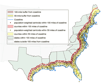
Table 1. Selected At-Risk Populations in Gulf of Mexico and Atlantic Ocean coastal zones, by Distance From the Coastline, United States, 2000a
        At-Risk Populations Distance from Coastlineb
        ≤50 miles, No. of People ≤100 miles, No. of People >100 miles, No. of People
        Old and young 15,807,599 18,204,359 9,049,178
        <5 y of age 5,269,967 6,069,337 3,206,434
        ≥65 y of age 10,537,632 12,135,022 5,842,744
        Below poverty level (%) 9,585,589 (12.0) 11,409,425 (12.4) 6,402,990 (13.5)
        School-aged population (total) 21,356,614 24,563,563 12,659,167
        Nursery school 1,494,064 1,696,568 829,584
        Kindergarten 1,149,218 1,328,574 698,459
        Elementary school 9,303,221 10,755,108 5,619,833
        High school 4,519,507 5,231,149 2,691,489
        College 4,890,604 5,552,164 2,819,802
        Hospital inpatientsc 177,787 208,246 117,036

        a Data are from the U.S. Census Bureau (12) and the American Hospital Association (13).
        b Measured by population-weighted centroids.
        c Based on 70% bed occupancy.

        Return to your place in the text
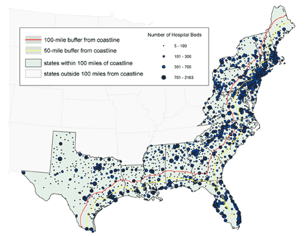
Table 2. Number of Hospitals and Hospital Beds and Workers in 21 States and the District of Columbia, by Distance From the Coast, United States, 2000a
        State or District Distance From Coastlineb
        ≤50 Miles, No. ≤100 Miles, No. >100 Miles, No.
        Total
        Hospitals 1,189 1,521 1,161
        Hospital Beds 253,891 297,494 167,081
        Workers 1,313,786 1,529,468 816,505
        Alabama
        Hospitals 15 35 86
        Hospital Beds 2,990 4,626 13,328
        Workers 11,357 17,640 59,546
        Connecticut
        Hospitals 46 47 NA
        Hospital Beds 8,862 8,940 NA
        Workers 51,430 51,714 NA
        Delaware
        Hospitals 11 11 NA
        Hospital Beds 2,237 2,237 NA
        Workers 16,332 16,332 NA
        District of Columbia
        Hospitals 16 16 NA
        Hospital Beds 4,670 4,670 NA
        Workers 28,623 28,623 NA
        Florida
        Hospitals 209 219 NA
        Hospital Beds 48,453 50,419 NA
        Workers 224,536 230,866 NA
        Georgia
        Hospitals 19 60 116
        Hospital Beds 2,597 7,214 18,558
        Workers 12,475 35,940 96,033
        Louisiana
        Hospitals 102 118 59
        Hospital Beds 12,699 14,191 6,229
        Workers 59,261 64,342 25,945
        Maine
        Hospitals 35 39 3
        Hospital Beds 3,420 3,542 164
        Workers 22,492 23,242 1,423
        Maryland
        Hospitals 67 70 4
        Hospital Beds 13,692 14,131 467
        Workers 80,081 82,432 2,395
        Massachusetts
        Hospitals 92 113 NA
        Hospital Beds 19,033 21,758 NA
        Workers 122,892 137,682 NA
        Mississippi
        Hospitals 12 27 80
        Hospital Beds 1,892 3,622 10,497
        Workers 8,598 16,071 38,048
        New Hampshire
        Hospitals 18 31 1
        Hospital Beds 2,212 3,091 16
        Workers 13,447 20,537 100
        New Jersey
        Hospitals 94 94 NA
        Hospital Beds 27,453 27,453 NA
        Workers 122,382 122,382 NA
        New York
        Hospitals 130 142 112
        Hospital Beds 44,160 46,251 19,863
        Workers 239,885 247,274 105,345
        North Carolina
        Hospitals 32 58 84
        Hospital Beds 5,075 10,063 15,946
        Workers 25,086 52,630 88,435
        Pennsylvania
        Hospitals 85 135 118
        Hospital Beds 18,942 27,242 17,960
        Workers 99,945 144,892 96,533
        Rhode Island
        Hospitals 16 16 NA
        Hospital Beds 3,293 3,293 NA
        Workers 17,748 17,748 NA
        South Carolina
        Hospitals 24 52 30
        Hospital Beds 3,124 7,890 4,155
        Workers 16,374 40,408 22,246
        Texas
        Hospitals 104 150 360
        Hospital Beds 17,666 21,557 45,585
        Workers 87,908 104,928 212,164
        Vermont
        Hospitals NA 6 11
        Hospital Beds NA 376 1,214
        Workers NA 1,933 9,572
        Virginia
        Hospitals 62 77 37
        Hospital Beds 11,421 14,142 6,223
        Workers 52,934 68,159 24,508
        West Virginia
        Hospitals NA 5 60
        Hospital Beds NA 786 6,876
        Workers NA 3,693 34,212

        NA indicates not applicable.
        a Data are from the American Hospital Association (13).
        b Measured by population-weighted centroids.

        Return to your place in the textTable 3. Estimated Numbers of People With Selected Medical Conditions in 21 states and the District of Columbia, by Proximity to the Gulf of Mexico and Atlantic Ocean Coastlinesa
        State, District Distance From Coastlineb
        ≤50 Miles ≤100 Miles
        Total
        High blood pressure 2,181,000 2,639,000
        Taking blood pressure medication 1,271,000 1,532,000
        High blood cholesterol 2,120,000 2,740,000
        Heart attack 2,328,000 2,787,000
        Heart disease 2,577,000 3,067,000
        Stroke 1,489,000 1,773,000
        Diabetes 662,000 801,000
        Asthma 998,000 1,177,000
        Pregnancy 113,000 130,000
        Alabama
        High blood pressure 19,000 32,000
        Taking blood pressure medication 13,000 23,000
        High blood cholesterol 15,000 28,000
        Heart attack 26,000 41,000
        Heart disease 15,000 29,000
        Stroke 11,000 24,000
        Diabetes 5,000 10,000
        Asthma 7,000 11,000
        Pregnancy 1,000 2,000
        Connecticut
        High blood pressure 67,000 67,000
        Taking blood pressure medication 48,000 48,000
        High blood cholesterol 68,000 68,000
        Heart attack 87,000 87,000
        Heart disease 113,000 113,000
        Stroke 44,000 44,000
        Diabetes 21,000 21,000
        Asthma 40,000 40,000
        Pregnancy 4,000 4,000
        Delaware
        High blood pressure 21,000 21,000
        Taking blood pressure medication 14,000 14,000
        High blood cholesterol 19,000 19,000
        Heart attack 28,000 28,000
        Heart disease 31,000 31,000
        Stroke 17,000 17,000
        Diabetes 5,000 5,000
        Asthma 8,000 8,000
        Pregnancy 1,000 1,000
        District of Columbia
        High blood pressure 15,000 15,000
        Taking blood pressure medication 11,000 11,000
        High blood cholesterol 18,000 18,000
        Heart attack 13,000 13,000
        Heart disease 13,000 13,000
        Stroke 14,000 14,000
        Diabetes 6,000 6,000
        Asthma 11,000 11,000
        Pregnancy 1,000 1,000
        Florida
        High blood pressure 494,000 505,000
        Taking blood pressure medication 289,000 295,000
        High blood cholesterol 412,000 431,000
        Heart attack 653,000 676,000
        Heart disease 718,000 744,000
        Stroke 393,000 403,000
        Diabetes 172,000 178,000
        Asthma 229,000 238,000
        Pregnancy 29,000 29,000
        Georgia
        High blood pressure 28,000 59,000
        Taking blood pressure medication 13,000 32,000
        High blood cholesterol 17,000 48,000
        Heart attack 21,000 56,000
        Heart disease 22,000 46,000
        Stroke 18,000 47,000
        Diabetes 7,000 16,000
        Asthma 9,000 20,000
        Pregnancy 1,000 2,000
        Louisiana
        High blood pressure 67,000 75,000
        Taking blood pressure medication 47,000 54,000
        High blood cholesterol 52,000 57,000
        Heart attack 80,000 85,000
        Heart disease 91,000 101,000
        Stroke 55,000 60,000
        Diabetes 29,000 32,000
        Asthma 35,000 38,000
        Pregnancy 3,000 3,000
        Maine
        High blood pressure 39,000 39,000
        Taking blood pressure medication 19,000 19,000
        High blood cholesterol 36,000 36,000
        Heart attack 42,000 42,000
        Heart disease 39,000 39,000
        Stroke 22,000 22,000
        Diabetes 12,000 12,000
        Asthma 22,000 22,000
        Pregnancy 2,000 2,000
        Maryland
        High blood pressure 153,000 163,000
        Taking blood pressure medication 98,000 103,000
        High blood cholesterol 188,000 192,000
        Heart attack 169,000 174,000
        Heart disease 168,000 174,000
        Stroke 98,000 101,000
        Diabetes 54,000 55,000
        Asthma 93,000 95,000
        Pregnancy 10,000 10,000
        Massachusetts
        High blood pressure 120,000 146,000
        Taking blood pressure medication 73,000 91,000
        High blood cholesterol 116,000 140,000
        Heart attack 155,000 203,000
        Heart disease 151,000 193,000
        Stroke 83,000 106,000
        Diabetes 33,000 41,000
        Asthma 73,000 88,000
        Pregnancy 6,000 7,000
        Mississippi
        High blood pressure 9,000 27,000
        Taking blood pressure medication 7,000 17,000
        High blood cholesterol 12,000 23,000
        Heart attack 13,000 36,000
        Heart disease 14,000 39,000
        Stroke 12,000 24,000
        Diabetes 4,000 10,000
        Asthma 5,000 10,000
        Pregnancy 1,000 2,000
        New Hampshire
        High blood pressure 18,000 22,000
        Taking blood pressure medication 11,000 15,000
        High blood cholesterol 27,000 35,000
        Heart attack 29,000 36,000
        Heart disease 35,000 43,000
        Stroke 17,000 23,000
        Diabetes 7,000 9,000
        Asthma 11,000 15,000
        Pregnancy 1,000 1,000
        New Jersey
        High blood pressure 244,000 244,000
        Taking blood pressure medication 148,000 148,000
        High blood cholesterol 288,000 288,000
        Heart attack 233,000 233,000
        Heart disease 282,000 282,000
        Stroke 139,000 139,000
        Diabetes 64,000 64,000
        Asthma 91,000 91,000
        Pregnancy 10,000 10,000
        New York
        High blood pressure 267,000 283,000
        Taking blood pressure medication 152,000 165,000
        High blood cholesterol 346,000 361,000
        Heart attack 254,000 266,000
        Heart disease 292,000 314,000
        Stroke 201,000 207,000
        Diabetes 83,000 87,000
        Asthma 132,000 140,000
        Pregnancy 19,000 19,000
        North Carolina
        High blood pressure 81,000 130,000
        Taking blood pressure medication 39,000 68,000
        High blood cholesterol 58,000 120,000
        Heart attack 61,000 110,000
        Heart disease 59,000 114,000
        Stroke 41,000 79,000
        Diabetes 22,000 42,000
        Asthma 25,000 52,000
        Pregnancy 3,000 7,000
        Pennsylvania
        High blood pressure 225,000 357,000
        Taking blood pressure medication 102,000 166,000
        High blood cholesterol 152,000 456,000
        Heart attack 119,000 224,000
        Heart disease 138,000 247,000
        Stroke 82,000 134,000
        Diabetes 48,000 84,000
        Asthma 82,000 129,000
        Pregnancy 7,000 10,000
        Rhode Island
        High blood pressure 23,000 23,000
        Taking blood pressure medication 17,000 17,000
        High blood cholesterol 26,000 26,000
        Heart attack 27,000 27,000
        Heart disease 31,000 31,000
        Stroke 15,000 15,000
        Diabetes 7,000 7,000
        Asthma 13,000 13,000
        Pregnancy 1,000 1,000
        South Carolina
        High blood pressure 61,000 100,000
        Taking blood pressure medication 28,000 53,000
        High blood cholesterol 42,000 88,000
        Heart attack 42,000 86,000
        Heart disease 37,000 77,000
        Stroke 30,000 62,000
        Diabetes 13,000 27,000
        Asthma 13,000 28,000
        Pregnancy 2,000 4,000
        Texas
        High blood pressure 99,000 149,000
        Taking blood pressure medication 65,000 93,000
        High blood cholesterol 93,000 134,000
        Heart attack 146,000 201,000
        Heart disease 157,000 216,000
        Stroke 102,000 135,000
        Diabetes 38,000 51,000
        Asthma 44,000 59,000
        Pregnancy 6,000 7,000
        Vermont
        High blood pressure NA 5,000
        Taking blood pressure medication NA 2,000
        High blood cholesterol NA 4,000
        Heart attack NA 4,000
        Heart disease NA 4,000
        Stroke NA 2,000
        Diabetes NA 1,000
        Asthma NA 2,000
        Pregnancy NA 1,000
        Virginia
        High blood pressure 131,000 172,000
        Taking blood pressure medication 77,000 95,000
        High blood cholesterol 135,000 163,000
        Heart attack 130,000 154,000
        Heart disease 171,000 207,000
        Stroke 95,000 113,000
        Diabetes 32,000 41,000
        Asthma 55,000 65,000
        Pregnancy 5,000 6,000
        West Virginia
        High blood pressure NA 5,000
        Taking blood pressure medication NA 3,000
        High blood cholesterol NA 5,000
        Heart attack NA 5,000
        Heart disease NA 10,000
        Stroke NA 2,000
        Diabetes NA 2,000
        Asthma NA 2,000
        Pregnancy NA 1,000

        NA indicates not applicable.
        a Data are from the Behavioral Risk Factor Surveillance System (8-11).
        b Measured by population-weighted centroids.

        Return to your place in the text
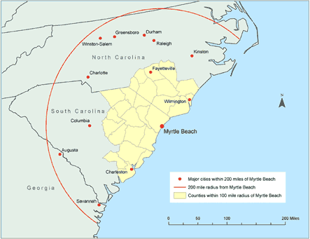
Table 4. Selected At-Risk Populations and Available Resources Within 100-mile Radius of Myrtle Beach, South Carolinaa
        Community Characteristics No. ≤100 Miles From Coastlineb
        At-Risk Populations
        Total population 2,244,538
        <5 y of age 153,529
        ≥65 y of age 258,835
        Below poverty level (%) 359,126 (16.0)
        School-aged children (total) 597,453
        Nursery school 39,054
        Kindergarten 34,130
        Elementary school 270,921
        High school 131,082
        College 122,266
        High-risk adults 443,000
        High blood pressure 94,000
        Taking blood pressure medication 20,000
        High blood cholesterol 76,000
        Heart attack 73,000
        Heart disease 69,000
        Stroke 51,000
        Diabetes 28,000
        Asthma 30,000
        Pregnant 2,000
        Available resources
        Schools 1,067
        Hospitals 43
        Hospital beds 6,658
        Hospitalizations (70% bed occupancy) 4,661
        Hospital workers 38,118

        a Data are from the Behavioral Risk Factor Surveillance System (8-11), the U.S. Census Bureau (12), and the American Hospital Association (13).
        b Measured by population-weighted centroids.

        Back to top


        The findings and conclusions in this report are those of the authors and do not necessarily represent the official position of the Centers for Disease Control and Prevention.


         Home 

        Privacy Policy | Accessibility

        CDC Home | Search | Health Topics A-Z

        This page last reviewed March 30, 2012

        Centers for Disease Control and Prevention
        National Center for Chronic Disease Prevention and Health Promotion
         HHS logoUnited States Department of
        Health and Human Services


        国产精品久久久久久一级毛片